Types of Maps: Uses, Symbols, and More
Know More about Maps
To examine the features of the world, the subject of geography uses a variety of maps. Some maps are so widespread that even a kid can recognize them, while others are only used by experts in specific fields.
Simply defined, a map is a symbolic expression of a location's specific qualities, usually drawn on a flat surface. Maps are a visual representation of information about the world. They demonstrate the size and shape of countries, the locations of landmarks, distances between them to teach about the world, and many more.
There are hundreds of different maps in use around the globe. The majority of these maps fall into one of the two categories: reference maps and thematic maps.
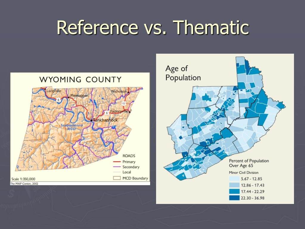
Geographic boundaries, physical elements of the Earth, and cultural aspects such as towns, cities, and roads are all depicted on reference maps. Reference maps include political maps, physical maps, road maps, topographic maps, time zone maps, geology maps, and zip code maps. For practically every country on the planet, a variety of reference maps have been made.
Thematic maps, on the other hand, show specialized information, such as the average rainfall distribution in a given area or the prevalence of a particular disease across a region. They show how a topic (the theme) varies over a geographical area. Other sorts of thematic maps include weather maps, income maps, and resource maps.


Political maps are one of the most commonly used kinds of maps. There are no topographic characteristics on a political map. They depict the geographical boundaries that separate governmental units such as countries, states, and counties. They portray important water features such as oceans, rivers, lakes, roads, and locations.
Political maps assist people in comprehending the world's geography. You can easily spot them in classrooms and offices. Political maps are the best fit to know the exact location of cities, boundaries, or even roads.
A physical map displays the landscape features of a location or country, such as rivers, mountains, forests, and lakes. Physical characteristics are generally depicted in a variety of colors. Rivers and lakes are depicted in blue, low-elevation areas in dark green, and as elevation rises, the color shifts to light green and then orange. In contrast, mountains are represented in brown.
In a physical map, political/state boundaries along with major roads and cities are shown. Sometimes, cultural information is included as well for the viewer’s ease.
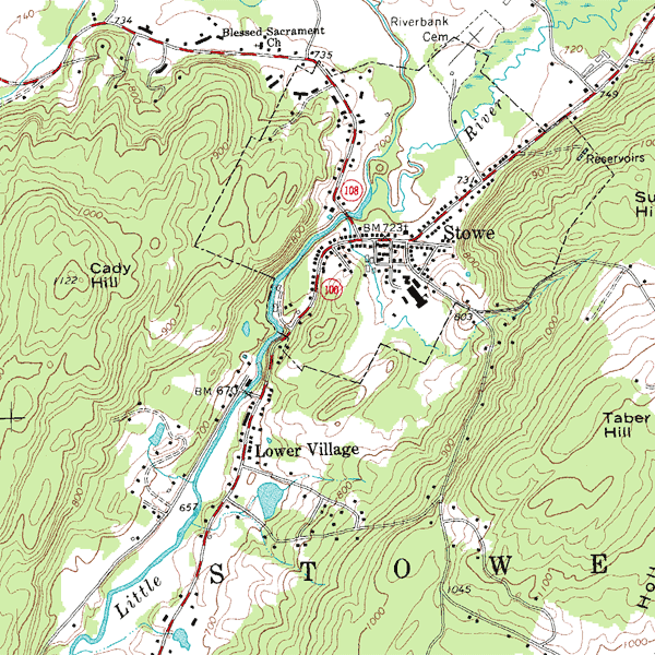
Topographic map are similar to physical maps in that they represent the physical characteristics of a location. Differences in height and changes in the terrain are depicted on topographic maps using contour lines rather than colors. They also show lakes, rivers, and streams.
Topographic maps are helpful for hunters, hikers, skiers, and others seeking outdoor pleasure. Geologists, surveyors, engineers, construction workers, landscape designers, architects, biologists, and many more professions, particularly those in the military, rely on them as well.
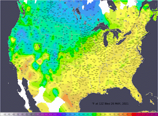
Weather maps are used by a huge number of people. Predicted temperatures, precipitation, storm warnings of various types, wind speed and direction, the possibility of precipitation, kind of precipitation, snow accumulation, frost prediction, and many other characteristics of weather are all displayed on them.
These maps are refreshed to ensure that they provide the most up-to-date information. Perhaps, weather maps are the most widely used thematic maps in the world. Different climates are shown in different colors. These are highly helpful for anyone who needs to know how weather changes may affect their travel, workday, recreation, and a variety of other activities.
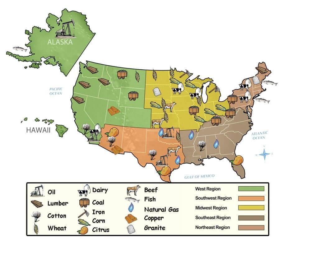
Economic or resource maps portray the various resources available in a given area and the predominant economic activity. They depict, for example, the kind of crops farmed and the minerals found in various locations. These maps could represent the countries with the most diamond production or the size of an oil or gas field.
Resource maps are significant because they assist governments in understanding their natural resource assets and the natural resource assets of potential allies and enemies. They're also useful for examining transportation opportunities and issues related to resource distribution and consumption.
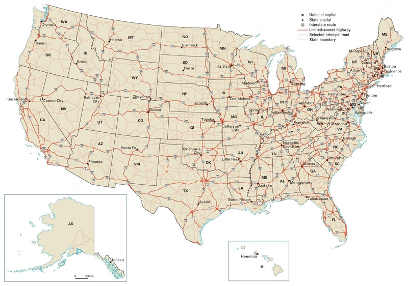
The most commonly used map is a road map, which indicates the many roads, highways, and railways in an area. It's a very detailed map that's typically used for navigation. Typically, city-by-city road maps are created. Road maps for an entire country are also available. However, they cannot be made particularly comprehensive.
Google Maps is now the most widely used internet mapping system in the world. The service also gives travel route directions in addition to maps. It can generate suggestions for driving, utilizing public transportation, walking, cycling, or traveling.
A frequent sort of thematic map is an income map. They depict socioeconomic disparities across a geographical area. The median household income is the usually mapped variable for an income map.
The United States Census Bureau publishes income maps for the entire country and individual states regularly. After each major census, the Bureau updates its set of income maps and makes them available to the public. "Change in income maps" is another service provided by the Census Bureau. These maps help know which sections of the country have witnessed economic development or decline over a while.
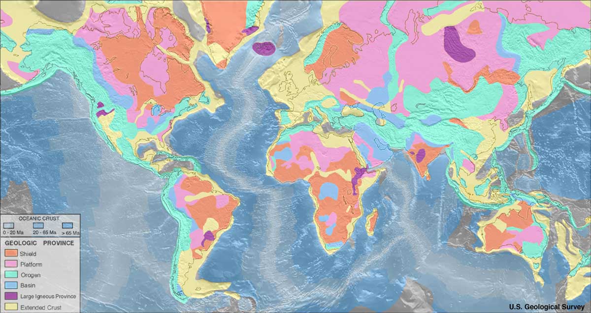
Geologic maps depict the types of rocks and sediments found directly underneath a geographic area's surface. Geologists in the field identify, sample, and measure the rocks to create geologic maps.
Many types of work require the use of geologic maps as a data source. Construction materials are made from specific rock types, and a geologic map illustrates where they are found on the surface.
Maps contain a lot of information. Maps usually have the following elements:
Learn about What is Map Scale?
At the first glance, reading a map may seem difficult. But, with the help of symbols, it is made easy. These symbols and elements in a map help us easily detect the features and examine the map more conveniently. You can try and read this zoo map with keys. Have fun!
From navigation to demonstrating ownership to presenting information, the versatility of maps is one of its most appealing features. Maps are used all over the world to have a better understanding of the world as well as its features. Different types of maps are used for various purposes. In the article above, many of these are discussed.
Creating a map is super easy with EdrawMax. The quick and easy-to-use interface and the gamut of editing tools can assist in creating one in a blink.